Spider map
A spider map is a schematic diagram of bus services serving a particular locality, as used by Transport for London since 2002. The maps were designed by T-Kartor. Generally mounted on the vertical surfaces of bus shelters it enables potential travellers to select the correct stop to board a bus, and the correct one to alight at.
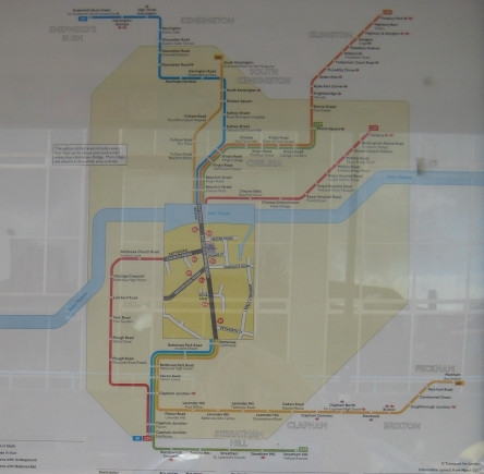
[...] At the centre of the map is a rectangular area with a yellow background which shows the local street layout and bus stops labelled with letters (A to Z, and if necessary AA to ZZ) of all the bus-stops in the local area. Beyond this is a schematic bus map for an area about 2 kilometres (1.2 mi) radius with a pale yellow background, which shows all bus stops in their relative positions. Further out of the map shows the remainder of the route against a white background, but without showing all bus stops. Bus routes themselves are show as distinctive coloured lines, and are clearly numbered.
Source: [Wikipedia - Spider map](http://en.wikipedia.org/wiki/Spider_map)